Mission Accomplished
SUMMARY: Glacier Point hike done!
The Plan
My estimated schedule was this:* 5:45 a.m. Leave home.
* 6:30 a.m. Meet at Fremont BART station and carpool to Yosemite.
* 10:30 a.m. Arrive at trailhead for Four-Mile Trail and head out.
* 2:30 Arrive at Glacier Point.
* 3:30 Leave Glacier Point.
* 5:30 Arrive back at car.
* 9:30 Arrive back at Fremont.
* 10:15 p.m. Arrive home.
Welllll you know how it goes. I really wanted to check out Bridalveil Falls on the way by to see how much water there was, The Other Ellen (my adventurous coconspirator) was interested in the rock textures for her artwork, we needed new maps, we needed to visit the (really pee-yew!) biffies... then I wasn't quite as ready for the hike (physically) as I thought I might be...
Dang muscles
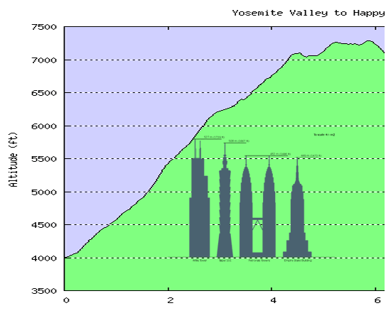
I knew that 3200 feet of straight up would be hard on my muscles and that back down would be hard on my knees, but I thought I had allowed sufficient time; 6 hours is about an average round trip, and we're both in reasonable hiking condition.But nuuuuuuu, by halfway up my up-going muscles were shaky enough that I had to stop frequently as I got to where I could barely lift my feet off the ground. The rest of me felt fine, though. We stopped often anyway for photo ops, but I added more stops than that. The Other Ellen's GPS claimed that we spend only 2:38 actually moving on the way up, but I find that hard to believe--it took us 5 hours total, which means that we were stopped fully half the time? Dunno...
I was pretty good for about a third of the way down, then my legs began their transmogrification to quivering rubber--the couple of times I stopped to take a photo, they were shaking so badly that I couldn't hold the camera even close to still--and then they just started hurting. Not the knees so much (although they weren't happy), but more the thighs and calves because it was so steep and slippery that I operated in a knees-bent mode most of the way down, no normal striding at all. By the last mile or two, I had to stop every few minutes to rest as my legs were on the verge of collapsing under me.
I made it to the car, but if it had been another mile, it's unlikely I'd have managed it--I was already swinging my legs into position each step rather than lifting, using my trekking pole to drag myself. Sounds lovely, eh? Needed more conditioning-- On the other hand, I was a good distance ahead of The Other Ellen (TOE) and she didn't seem to be itching to go faster, either.
But the rest of me still felt great!
The Reality
So here's what it really was:* 5:45 a.m. Leave home.
* 6:30 a.m. Meet at Fremont BART station.
* 6:45 Head to Yosemite.
* 10:20 Stop at Bridalveil Falls.
* 11:20 a.m. Arrive at trailhead for Four-Mile Trail.
* 11:45 Head out. Why did it take us so long there? Broken bootlace, couple of photos, I dunno, just took a while to get it together.
* 4:45 Arrive at Glacier Point.
* 6:00 Leave Glacier Point.
* 8:30 Arrive back at car. Divest hiking gear, find snacks, etc.; drop off found hiker at her car, etc.
* 1:17 a.m. Arrive back at Fremont.
* 1:50 a.m. Arrive home.
General trip notes
It's always fun traveling with someone with whom you can chat the whole trip away. Although TOE and I have known each other for years, have been in the same agility class off and on, read each other's blogs, and email quite a bit, still, this was a great chance to get to know more about each other.And we didn't talk about dogs or agility nearly as much as one might have expected!
We seemed to travel and hike well together. Note to self: Worth doing more.
It had been 99F in Yosemite Valley on Thursday, 90 on Friday, so I was hoping it wouldn't be too bad for us. Turned out to be a lovely temperature--I never felt the need to don my fleece until we got back to the car.
The problem was that the air was therefore extremely hazy. Add to that a high, bright overcast, and there was so much glare looking out across the valley that I knew that all my scenic photos would be iffy. Only so much I can do in photoshop.
I did remember to put on sun lotion despite the overcast, so had no burn at all.
It sprinkled on us a couple of times, but never enough to get us or anything else wet.
It was disappointing that there was NO water, absolutely none, coming over Yosemite Falls, and this trail has the best views of those Falls from anywhere in the park. Guess that means I'll have to do it again. On the other hand, it was fascinating in a morbid way to keep seeing those dry, naked cliffs sans cascade.
We had vowed to have ice cream at the snack shack at the top. Man, my ice cream bar tasted better than just about anything! I didn't really feel hungry most of the day--got stomach pangs once so we stopped so I could eat half my sandwich; my stomach knew better than my brain.
We were absolutely the last ones to leave Glacier Point to head back down, and a German medical student leaving at about the same time slowed down to hike with us, for companionship both for the mere emptiness of the trail at this time of the evening and the fact that she didn't have a flashlight with her. If she had just passed us, though, she might have made it down before complete dark on her own.
Although she was wearing tennis shoes rather than hiking boots; this was a problem on this trial. In the old days, Yosemite paved *everything* to make it easier for people to get places. Not too many decades ago, they realized that paving difficult and dangerous routes to make it easier for every numbskull in the world to get himself into trouble wasn't a good idea, so they've been allowing the asphalt to gradually break down and go away.
The problem on this trail is that it was steep, so the sand and gravel on the unbroken stretches of asphalt made every step like walking on marbles or slick ice. We slipped even with our hiking boots and trekking poles; her shoes had a much tougher time of it going down. TOE had two poles and lent her one.
It was fun to have a third person to chat with. She was smart and funny and we talked about vocabulary and languages and medical training in Germany vs. in U.S. and travel and all kinds of things. We exchanged email addresses--best of friends after two and a half hours together on the trail! Amazing how that works. A year from now we'll probably have no recollection at all of the people we just met.
Not my beautiful dogs
This hike surely would have tuckered out the dogs, but in addition to them being prohibited, there were many reasons for them not to be there:
* Small wild lifes of which I got some snapshots
* Rattlesnake
* Sheer cliffs
Fan mail Q&A
My dad sent me some questions. Here ya go:How was your companion? (See above.)
Did you have bear problems? Bare problems? Beer problems? We never saw bears. We were careful not to leave anything resembling food in the car. We did not encounter the guy who likes to hike in the nude. And no beer involved; in fact, TOE and the German hiker talked about wines!
Did you suffer from mountain lassitude? (Private joke.) I think if anything it was Drought Lassitude.
You mention ice cream - No champagne because Binder wasn't there? (Continuing the private joke. If you haven't read The Ascent of Rum Doodle, do so--family favorite.)
Did you get sun-burned? Nope. (See above.)
Run short of breath? Only once--on the drive in, we stopped & I jogged down the road for a photo shot. Realized I was a little short on breath. Took a hit from the albuterol and was fine the rest of the time.
Get cramps? Nope.
Many people going up? Down? Did you see any going both directions as you did? Or the other way - starting from the top for the round trip? As we were going up, people passed us all day going in both directions. We must've been the slowest ones on the trail. I'd guess we saw at least three dozen people on the trail. One couple passing us going up asked whether most people started at the bottom; they had started at the top, gone down, and were heading up again. They still passed us briskly.
If you did it again, would you take the bus one way - which way? Hmm, hard question. If I were to do it again--which is starting to be a given, now realizing what great Yosemite-Falls-with-water shots I couldn't get this time--I'd still start out going up. If I were to take the bus, it would be going back down. But that seems so much like cheating (or at least wimping out) at that point!
I've been trying to load a few sample photos to go with this post, PLUS photos of dogs that WERE there, at the top of Glacier Point, but Blogger has been giving me (and others) grief for the last 2 or 3 weeks about finishing its uploads, and I don't have time for hacking by hand, so you'll just have to go to our photo sites for ALL the photos:
* Mine: Glacier Point Hike photos with brief narrative. If you have the bandwidth for it, using the Slideshow button in the upper right is probably the way to go (you'll still see most of my text, but the links I've embedded don't show up in the slideshow, if you care).
* TOE's: Hike photos with sparse comments; lots of boulders because she's interested in the shapes and textures, but also plenty of lovely view shots. And lots of me for a change.
* TOE's brief blog post about the prequel to this trip. Complete list of labels
posted by Elf @ 1:13 PM (View as individual page)
21 Comments
Links to this post
![]()
![]()

